Omnitracs Navigation 5.8 Release Notes
New Features & Enhancements
The following new features are in this release of Omnitracs Navigation.
- You can have real time traffic conditions considered when a new route path is considered for the driver.
- Some pop-up prompts have been redesigned to provide to a consistent look.
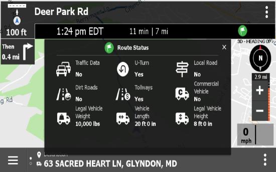
- The Route Status window has been updated so you can easily see which path setting has been deviated from or followed.
- The junction view has been redesigned. an exit sign is now displayed over top the map and will auto close if you do not close it manually.
- New path settings that the driver can set have been added to allow for real time traffic to be applied to your path and to set a time limit that determines how often a path is recalculated.
- Omnitracs Navigation prompts the worker if there is a faster path and will automatically re-route the path, unless the worker dismisses the suggestion. The re-route suggestion will be read aloud and displayed on the screen.
- Roads with high traffic display in red. Roads with medium traffic display in orange.
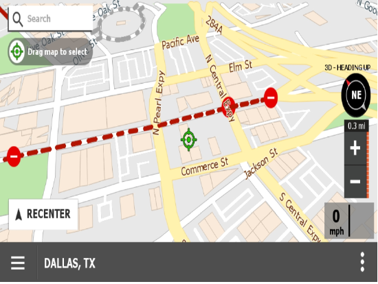
- The maps now display disabled and blocked roads.
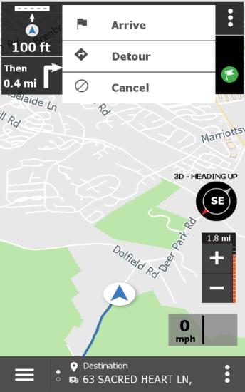
- Access to the Detour, Arrive, and Cancel options have been moved to the kabob menu at the top of the map. Press the kabob menu and the options display in a list.
- More information is provided when receiving turn-by-turn audible directions.
- Waypoints are now passed from Roadnet Mobile to Omnitracs Navigation. You can choose to enforce waypoints or allow re-routing using real time traffic.
- Building outlines can now be seen on the map.
Using Real Time Traffic
Note: If you are interested in using real time traffic, contact Omnitracs Customer Support to have the option enabled for your organization.
As anyone involved in transportation knows, the current traffic conditions can affect the best path for your driver to take. Now, you can use real time traffic data to affect changes made to your routes in Omnitracs, as well as how the routes may appear on a map.
- If you are using Omnitracs Navigation, the route paths can be changed based on the real time traffic data. In addition, the map will indicate the traffic levels.
- If you are using Autonomous Optimization, real time traffic will be considered when the routes are re-sequenced or unassigned orders are assigned to routes.
- In FleetView, you can choose to show the real time traffic on the map.
Setting the Options for Your Regions
If you want to use real time traffic with Omnitracs Navigation or with Autonomous Optimization, you need to configure it for your regions.
- Click the Administration icon to open Administration.
- Click the green button and scroll to Regions, the Regions list opens. To add a new region, click [Add]; to update an existing region click the Edit icon. The Region window opens.
- Click Driving Options on the left side; the Driving Options page opens.
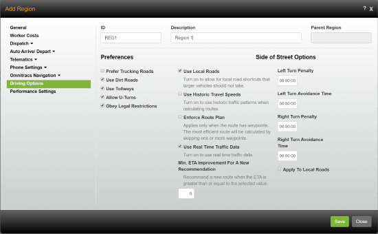
- If you are using waypoints to ensure the route follows the specified path and want that path followed even if traffic conditions change, check Enforce Route Plan. If the path can be changed due to changing traffic conditions, do not check Enforce Route Plan.
Note: This setting only applies to Omnitracs Navigation. - If you want to have current traffic conditions considered when calculating a route, check Use Real Time Traffic Data.
Note: Real Time Traffic Data is not used when calculating Planning routes. - If you only want the driver presented with a new route if it saves a defined amount of time, enter the minimum number of minutes that the change will save in Min ETA Improvement for a New Recommendation.
Note: This option is only available if Enforce Route Plan is not selected and Use Real Time Traffic Data is selected. - Click [Save] to save the settings.
Setting Real Time Traffic from the Mobile Device
If you would like your workers to be able to define their own settings for real time traffic, they can be changed on the mobile device at Menu > Path Settings.
The worker must enable Use Real Time Traffic, to have the current traffic conditions when calculating a route. If the worker only wants a new path suggested if it saves a defined amount of time, after enabling real time traffic, the worker must enter the minimum number of minutes that the change will save in Minimum ETA Improvement for a New Recommendation.
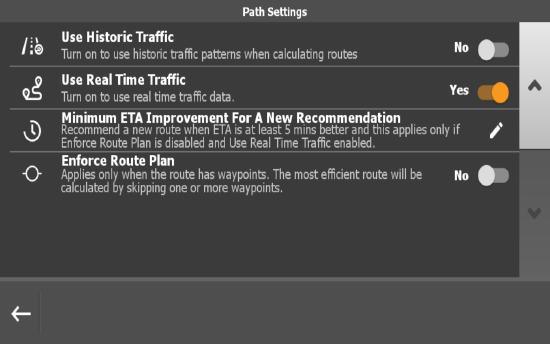
Notes: The Minimum ETA Improvement For A New Recommendation option is only available if Enforce Route Plan is disabled and Use Real Time Traffic is enabled.
If the worker wants the original path to be followed without variation, Enforce Route Path must be enabled.
On the mobile device, when there is a faster path available, how much time is saved with the new path suggestion is read aloud and displays on the screen. The path is automatically re-routed unless the worker dismisses the suggestion.
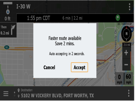
When looking at the map, the traffic icon designates that a path is based on real time traffic data. The traffic icon is crossed out when real time traffic is disabled or if there is trouble downloading the traffic data.
![]()
The roads also display differently when real time traffic has been applied to the path. The color over the road is different, based on how heavy the traffic is. The worker will see a red layer if traffic is heavy, while orange displays if there is medium level traffic.
Displaying Real Time Traffic in FleetView
To see real time traffic conditions on the map, click the arrow button and check Traffic. The real time traffic conditions appear on the map, and the road segments are colored to reflect the traffic conditions:
Green - traffic is not delayed
Orange - traffic is delayed
Red - traffic is stopped
Enhancements to Omnitracs Navigation
Many updates have been made to Omnitracs Navigation for the 5.8 release. The following enhancements have been included:
- The junction view has been redesigned. Previously when you approached an on or off ramp that was part of your path, the display changed to show just an exit sign. Now the sign displays to the side of the map, so you can still see the map. If you do not close it manually, the junction sign automatically closes once you pass through the on/off ramp.
- Turn-by-Turn audible directions have been expanded. When previously you might only hear "turn left," now the road name and distance are included with the instruction.
- Waypoints are now passed from Roadnet Mobile, ensuring that the paths provided in both Roadnet Mobile and Omnitracs Navigation are the same. If you always want the path followed, even if Omnitracs Navigation can provide a better path due to changing traffic conditions, be sure to check Enforce Route Path, at Menu > Path Settings.
Updated Pop-up Prompts
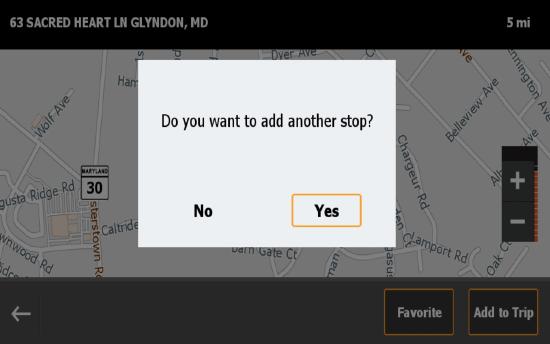
In an effort to make the look and feel of Omnitracs Navigation more consistent throughout the application, pop-up boxes will change. The expected answer to a prompt will display on the bottom right of the pop-up with an orange box around it.
Route Status Enhanced
To make it clearer which path and vehicle settings are being followed or violated, the Route Status window has been enhanced. You can now see the setting name, along with how it is set. If the path violates a setting, it is highlighted in orange.
Options Moved So You Can See More Map
So that more of the map can be seen, the Arrive, Detour, and Cancel options have been moved to the kabob menu at the top of the map. This is especially helpful in portrait mode where map space is less available. Press the kabob menu and the options display in a list.
Distinguishing Buildings on the Map
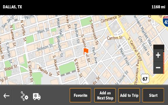
So you can determine where on a street a building is located, you can choose to view the outline of buildings on the map. To see buildings on the map, go to Menu > Settings > Map Settings > Map Style and turn on Show Buildings.
More Road Types Display on the Map
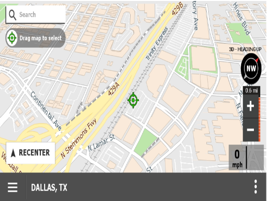
You can now see disabled and blocked roads on the map. Disabled roads appear as a gray stripes where the road runs. Blocked roads show as red stripes where the road runs.
Software Corrections
| Issue Key | Release Notes |
|---|---|
| RPE-5080 | There was an issue where the Region settings for Omnitracs Navigation were not being saved. This has been corrected. |
| RPE-7785 | There was an issue where the Navigation Region settings were not always saving properly. This has been corrected. |
| RPE-8377 | There was an issue that was causing the traffic speed prompt to cover the quick menu. This has been corrected. |
| RPE-8097 | There was an issue that was causing Navigation to crash if there was an invalid waypoint on a trip. This has been corrected. |
| RPE-7553 | The break clock was showing the wrong amount of time until a break is needed. This has been corrected. |
| RPE-7307 | There was an issue causing the screen to go blank when departing the origin and navigating to the first stop. This has been corrected. |
| RPE-3825 | There was an issue in Portrait mode where the Add to Trip option was not visible in the menu. This has been corrected. |
| RPE-5073 | There was an issue that could cause the application to crash when changing orientation from portrait to landscape, or landscape to portrait. This has been corrected. |
| RPE-1217 | There was an issue where some waypoints were not being properly placed along highways. This has been corrected. |
| RPE-2332 | There was an issue where the destination icon was appearing for waypoints in the next turn and next next turn window. This has been corrected. |
| RPE-8262 | Several improvements were made to stabilize the integration between Drive and Navigation. |
| RPE-7870 | When a depart actions is completed in Drive, the same stop information was sent to OT Navigation multiple times, causing OT Navigation to recalculate the route and lose track of the current progress. This has been corrected. |
| RPE-5422 | A change was made so that when Navigation receives a request from Drive or others app, to cancel a route, it will cancel it, without asking for a second confirmation. |
| RPE-5226 | There was an issue that was preventing some users from being notified about railway crossings. This is fixed in the 2020.1 map version, but not in the prior map versions. |
| RPE-8023 | OT Navigation will now attempt to read the phone number or serial number for Android OS 10 devices to pre-authenticate or auto-enable the application. Additional changes to Android OS 10 may block us in getting those device identifiers. |